Costa Rica Beaches
Those seeking relaxation on a sandy beach will not find it in Monteverde's 5,000 ft mountains. However, if you would like to pair Monteverde with a beach destination during your trip, there are great options along the Pacific coast.
Prefer to leave the driving to the professionals?
Book transportation, and enjoy scenic views while the locals drive you around.
Below we have included 4 separate maps with driving directions to many
of the
beaches
that can be easily reached on the way to or coming from Monteverde. We
recommend researching
beachfront and ocean view hotels
or message us for guidance.
Unfortunately, the Caribbean beaches are not readily accessible by
ground transportation from the Monteverde area, but in Costa Rica
nothing is impossible.
Table of Contents
- Nicoya Peninsula
- Central Pacific
- Guanacaste
Beaches of Samara & Carrillo Costa Rica
Samara Beach & Carrillo Beach are some of the nicest beaches in all of Costa Rica and happen to be some of the closest beaches to Monteverde. Other beaches in the area are Nosara & Punta Islita.
To and From Monteverde:
Samara
- Distance: 166 km
- Driving Time: 3.5 hours
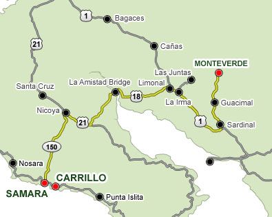
Driving Directions from Monteverde:
- From Santa Elena, head south for 33 km until you get to the Pan-American Highway. On the way, you must pass through the towns of Guacimal and Sardinal. This route is a bit longer but the road is in better condition than if you travel through Las Juntas.
- Continue on the Pan-American Highway for 32 km until you get to the Limonal Shell Gas Station. Then, turn left in direction to Nicoya, passing through La Amistad Bridge over the Tempisque River (64 km).
- In Nicoya, turn left, get into the city, and follow the sign that says Samara Beach, continuing for 37 km until you reach it.
Beaches of Montezuma, Mal Pais, & Santa Teresa Costa Rica
Both Montezuma and Mal Pais-Santa Teresa destinations are near the tip of the Nicoya Peninsula and are accessed from the car and passenger ferry that leaves from Puntarenas , which is only 70km from Monteverde.
To and From Monteverde:
Malpais
- Distance: 126 km
- Driving Time: 3.5 hours
Montezuma
- Distance: 119 km
- Driving Time: 3 hours

Driving directions from Monteverde:
Leg 1: Monteverde to Puntarenas (70 km)
- Drive from Monteverde, head south for 33 km until you get to the Pan-American Highway. In the road, you must pass through the towns of Guacimal and Sardinal.
- Once you get to the Pan-American Highway, turn left and continue for 21.5 km until you reach the intersection to Puntarenas and take the Costanera Highway (road #34).
- On the Costanera, just drive for 4.32 km and then turn right on the Puntarenas entry, then continue for 12 km until you reach the Puntarenas downtown.
- To find the ferry, just stay on the same street and drive straight for several blocks until you get to "La Punta," which is located when the road reaches the beach. Once you are in front of the beach, just turn right and drive around the beach for 200 meters, then you will see the line of cars and the dock at the left side.
Leg 2: Crossing on the ferry from Puntarenas
Suggested route:
Ferry Routes
- To Paquera: 2 hours - 19km
- Peninsular ADIP: 8:30 AM, 1:30 PM, 8:30 PM
- Naviera Tambor: 5:00 AM, 9:00 AM, 11:00 AM, 2:00 PM, 5:00 PM, 8:00 PM
- To Playa Naranjo: 1:10 hours - 12 km
- Coonatramar: 6:30 AM, 10:00 AM, 2:30 PM, 5:00 PM
Paquera to Montezuma (48 km)
Once you get off the ferry take the main street and turn left in the next intersection and drive for 40.7 km until you get the entrance to Montezuma then continue ahead for 6.7 km more until you get the main town. If you coming from Playa Naranjo, is the same route just add 20 km to get to Paquera.
Paquera to Malpais (55 km)
- Drive from Monteverde head south for 33 km until you reach the Pan-American Highway. On the road, you must pass through the towns of Guacimal and Sardinal.
- Once you get to the Pan-American Highway, turn left and continue for 21.5 km until you reach the intersection to Puntarenas, then take the Costanera Highway (road #34).
- On the Costanera, just drive for 4.32 km and then turn right in the Puntarenas entry, then continue for 12 km until you get to the Puntarenas downtown.
- To find the ferry, just stay on the same street and drive straight for several blocks until you get "La Punta" which is located when the road reach the beach. Once you are in front of the beach, just turn right and drive around the beach for 200 meters, then you will see the line of cars and the dock at the left side.
- Once you get off the ferry, take the main street and turn left on the next intersection, then drive for 40.7 km until you reach the entrance to Montezuma. Continue ahead for 6.7 km more until you get to the main town. If you are coming from Playa Naranjo, it is the same route — just add 20 km to get Paquera.
- Once you get off the ferry, take the main street and turn left on the next intersection. Drive for 52 km until you get to the Playa del Carmen intersection, then turn left and continue ahead for 3 km more until you reach the main town. If you are coming from Playa Naranjo, it is the same route, just add 20 km to get to Paquera.
Beaches of Jaco & Manuel Antonio Costa Rica
Jaco and Manuel Antonio are both located along the Central Pacific Coast. Jaco is 116km from Monteverde and Manuel Antonio is an additional 73km south of Jaco.
To and from Jaco & Manuel Antonio:
Jaco
- Distance: 116 km
- Driving Time: 3 hours
Manuel Antonio
- Distance: 190 km
- Driving Time: 4.5 hours
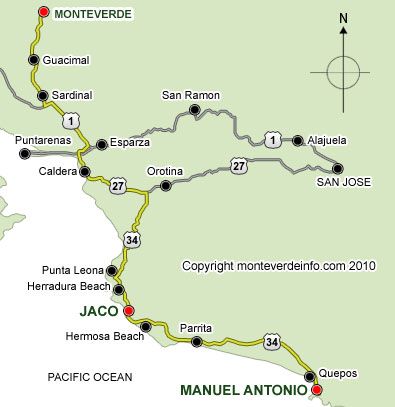
Driving Directions from Monteverde:
Going To Manuel Antonio
- Drive from Monteverde head south for 33 km until you get to the Pan-American Highway. On the road, you must pass through the towns of Guacimal and Sardinal.
- Once you reach the Pan-American Highway, turn left and continue for 21.5 km until you get to the intersection to Puntarenas, then take the Costanera Highway (road #34).
- Continue straight for 60 km, then you will reach the entrance to Jaco — on the right side. Continue for about 1.5 km more, and then you will be at Jaco town.
- Do not enter into Jaco, just keep on the same street and continue straight for 70 km more. You will pass through Parrita and then you will arrive to Quepos, the main town before Manuel Antonio.
- Once in Quepos, go around the town or follow the Manuel Antonio sign and for the next 6 km you will see the main Manuel Antonio hotels on both sides of the street.
Jaco To Manuel Antonio
- Do not enter into Jaco, just keep on the same street and continue straight for 70 km more. You will pass through Parrita and then you will arrive to Quepos, the main town before Manuel Antonio.
- Once in Quepos, go around the town or follow the Manuel Antonio sign and for the next 6 km you will see the main Manuel Antonio hotels at both sides of the street.
Beaches of Guanacaste Costa Rica
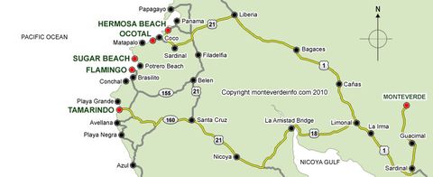
To far northwest lies the region of Guanacaste, Costa Rica has many sun-drenched beaches. Two of the more popular are Tamarindo and Hermosa.
To and from Guanacaste Beaches
Tamarindo
- Distance: 183 km
- Driving Time: 4 hours
Playa Hermosa
- Distance: 165 km
- Driving Time: 3.5 hours
Ocotal
- Distance: 173 km
- Driving Time: 3.5 hours
Flamingo
- Distance: 200 km
- Driving Time: 4.5 hours
